Cerberus Fossae
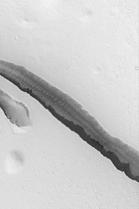
The Cerberus Fossae are a series of semi-parallel fissures on Mars formed by faults which pulled the crust apart in the Cerberus region. They are 1235 km across and centered at 11.28 °N and 166.37 °W. Their northernmost latitude is 16.16 °N and their southernmost latitude 6.23 °N. Their easternmost and westernmost longitudes are 174.72 °E and 154.43 °E, respectively. They can be seen in the Elysium quadrangle . [1]
Page Revisions
| Year | Metadata | Sections | Top Words | First Paragraph |
| 2018 |
83110 characters 2 sections 8 paragraphs 7 images 653 internal links 8 external links |
cerberus 0.621 fossae 0.340 lava 0.213 flood 0.151 discharges 0.141 faults 0.134 elysium 0.132 athabasca 0.129 fissures 0.127 behaved 0.109 m3s 0.109 rafted 0.098 trough 0.096 1235 0.092 hirise 0.089 |
The Cerberus Fossae are a series of semi-parallel fissures on Mars formed by faults which pulled the crust apart in the Cerberus region. They are 1235 km across and centered at 11.28 °N and 166.37 °W. Their northernmost latitude is 16.16 °N and their southernmost latitude 6.23 °N. Their easternmost and westernmost longitudes are 174.72 °E and 154.43 °E, respectively. They can be seen in the Elysium quadrangle . [1] |
|
| 2017 |
85565 characters 2 sections 9 paragraphs 7 images 655 internal links 12 external links |
cerberus 0.559 fossae 0.340 elysium 0.198 faults 0.150 fissures 0.143 plates 0.131 ice 0.124 m3s 0.122 lava 0.120 trough 0.108 locale 0.103 evidences 0.103 1235 0.103 hirise 0.100 area 0.097 |
The Cerberus Fossae are a series of semi-parallel fissures on Mars formed by faults which pulled the crust apart in the Cerberus region. They are 1235 km across and centered at 11.28 °N and 166.37 °W. Their northernmost latitude is 16.16 °N and their southernmost latitude 6.23 °N. Their easternmost and westernmost longitudes are 174.72 °E and 154.43 °E, respectively. They can be seen in the Elysium quadrangle . |
|
| 2016 |
42246 characters 2 sections 8 paragraphs 10 images 158 internal links 11 external links |
cerberus 0.564 fossae 0.343 faults 0.152 elysium 0.150 fissures 0.144 plates 0.132 ice 0.125 m3s 0.123 lava 0.121 trough 0.109 locale 0.104 evidences 0.104 1235 0.104 hirise 0.101 area 0.097 |
The Cerberus Fossae are a series of semi-parallel fissures on Mars formed by faults which pulled the crust apart in the Cerberus region. They are 1235 km across and centered at 11.28 °N and 166.37 °W. Their northernmost latitude is 16.16 °N and their southernmost latitude 6.23 °N. Their easternmost and westernmost longitudes are 174.72 °E and 154.43 °E, respectively. [1] Ripples seen at the bottom of the faults are sand blown by the wind. [2] The underlying cause for the faulting was magma pressure related to the formation of the Elysium volcanic field, located to the northwest. The faults pass through pre-existing features such as hills, indicating that it is a younger feature. [3] The formation of the fossae is suspected to have released pressurized underground water, previously confined by the cryosphere , with flow rates up to 2 × 10 6 m 3 s −1 , leading to the creation of the Athabasca Valles . [4] [5] [6] Marte Vallis is another channel that was formed from water released from Cerberus Fossae. [7] |
|
| 2015 |
42231 characters 2 sections 8 paragraphs 10 images 158 internal links 11 external links |
cerberus 0.567 fossae 0.344 elysium 0.151 fissures 0.145 plates 0.133 ice 0.126 m3s 0.124 lava 0.122 trough 0.109 locale 0.105 evidences 0.105 1235 0.105 faults 0.102 hirise 0.101 area 0.098 |
The Cerberus Fossae are a series of semi-parallel fissures on Mars formed by faults which pulled the crust apart in the Cerberus region. It is 1235 km across and centered at 11.28 °N and 166.37 °W. It's Northernmost Latitude is 16.16 °N and Southernmost Latitude 6.23 °N. Easternmost and Westernmost Longitudes are 174.72 °E and 154.43 °E respectively. [1] Ripples seen at the bottom of the fault are sand blown by the wind. [2] The underlying cause for the faulting was magma pressure related to the formation of the Elysium volcanic field, located to the northwest. The faults pass through pre-existing features such as hills, indicating that it is a younger feature. [3] The formation of the fossae is suspected to have released pressurized underground water, previously confined by the cryosphere , with flow rates up to 2 × 10 6 m 3 s −1 , leading to the creation of the Athabasca Valles . [4] [5] [6] Marte Vallis is another channel that was formed from water released from Cerberus Fossae. [7] |
|
| 2014 |
41465 characters 2 sections 8 paragraphs 10 images 158 internal links 10 external links |
cerberus 0.588 fossae 0.357 elysium 0.156 fissures 0.151 plates 0.138 ice 0.130 m3s 0.129 lava 0.126 trough 0.113 locale 0.109 evidences 0.109 faults 0.105 hirise 0.105 area 0.102 broken 0.098 |
The Cerberus Fossae are a series of semi-parallel fissures on Mars formed by faults which pulled the crust apart in the Cerberus region (9°N, 197°W). Ripples seen at the bottom of the fault are sand blown by the wind. [1] The underlying cause for the faulting was magma pressure related to the formation of the Elysium volcanic field, located to the northwest. The faults pass through pre-existing features such as hills, indicating that it is a younger feature. [2] The formation of the fossae is suspected to have released pressurized underground water, previously confined by the cryosphere , with flow rates up to 2 × 10 6 m 3 s −1 , leading to the creation of the Athabasca Valles . [3] [4] [5] Marte Vallis is another channel that was formed from water released from Cerberus Fossae. [6] |
|
| 2013 |
39958 characters 2 sections 8 paragraphs 11 images 159 internal links 10 external links |
cerberus 0.584 fossae 0.355 elysium 0.156 fissures 0.150 plates 0.137 ice 0.129 m3s 0.128 lava 0.125 trough 0.113 locale 0.108 evidences 0.108 faults 0.105 hirise 0.104 area 0.101 pressurised 0.099 |
The Cerberus Fossae are a series of semi-parallel fissures on Mars formed by faults which pulled the crust apart in the Cerberus region (9°N, 197°W). Ripples seen at the bottom of the fault are sand blown by the wind [1] . The underlying cause for the faulting was magma pressure related to the formation of the Elysium volcanic field, located to the northwest. The faults pass through pre-existing features such as hills, indicating that it is a younger feature [2] . The formation of the fossae is suspected to have released pressurised underground water, previously confined by the cryosphere , with flow rates up to 2 × 10 6 m 3 s −1 , leading to the creation of the Athabasca Valles . [1] [2] [3] Marte Vallis is another channel that was formed from water released from Cerberus Fossae. [4] |
|
| 2012 |
14461 characters 2 sections 6 paragraphs 7 images 14 internal links 6 external links |
cerberus 0.594 fossae 0.361 m3s 0.173 evidences 0.147 faults 0.142 pressurised 0.134 hypothesised 0.126 unconformity 0.117 lava 0.113 pack 0.109 hirise 0.106 athabasca 0.103 197 0.103 hitting 0.101 fissures 0.101 |
The Cerberus Fossae are a series of semi-parallel fissures on Mars formed by faults which pulled the crust apart in the Cerberus region (9°N, 197°W). Ripples seen at the bottom of the fault are sand blown by the wind [1] . The underlying cause for the faulting was magma pressure related to the formation of the Elysium Volcanic field, located to the northwest. The faults pass through pre-existing features such as hills, indicating that it is a younger feature [2] . The formation of the fossae is suspected to have released pressurised underground water, previously confined by the cryosphere , with flow rates up to 2 × 10 6 m 3 s −1 , leading to the creation of the Athabasca Valles . [1] [2] [3] |
|
| 2011 |
13384 characters 2 sections 6 paragraphs 7 images 14 internal links 6 external links |
cerberus 0.602 fossae 0.366 m3s 0.176 evidences 0.149 faults 0.144 pressurised 0.136 hypothesised 0.128 unconformity 0.119 pack 0.110 hirise 0.107 athabasca 0.104 197 0.104 hitting 0.103 fissures 0.103 stone 0.103 |
The Cerberus Fossae are a series of semi-parallel fissures on Mars formed by faults which pulled the crust apart in the Cerberus region (9°N, 197°W). Ripples seen at the bottom of the fault are sand blown by the wind [1] . The underlying cause for the faulting was magma pressure related to the formation of the Elysium Volcanic field, located to the northwest. The faults pass through pre-existing features such as hills, indicating that it is a younger feature [2] . The formation of the fossae is suspected to have released pressurised underground water, previously confined by the cryosphere , with flow rates up to 2 × 10 6 m 3 s −1 , leading to the creation of the Athabasca Valles . [1] |
|
| 2010 |
13162 characters 2 sections 6 paragraphs 7 images 13 internal links 5 external links |
cerberus 0.602 fossae 0.366 m3s 0.176 evidences 0.149 faults 0.144 pressurised 0.136 hypothesised 0.128 unconformity 0.119 pack 0.110 hirise 0.107 athabasca 0.104 197 0.104 hitting 0.103 fissures 0.103 stone 0.103 |
The Cerberus Fossae are a series of semi-parallel fissures on Mars formed by faults which pulled the crust apart in the Cerberus region (9°N, 197°W). Ripples seen at the bottom of the fault are sand blown by the wind [1] . The underlying cause for the faulting was magma pressure related to the formation of the Elysium Volcanic field, located to the northwest. The faults pass through pre-existing features such as hills, indicating that it is a younger feature [2] . The formation of the fossae is suspected to have released pressurised underground water, previously confined by the cryosphere , with flow rates up to 2 × 10 6 m 3 s −1 , leading to the creation of the Athabasca Valles . [1] |
|
| 2009 |
13234 characters 2 sections 6 paragraphs 7 images 13 internal links 5 external links |
cerberus 0.602 fossae 0.366 m3s 0.176 evidences 0.149 faults 0.144 pressurised 0.136 hypothesised 0.128 unconformity 0.119 pack 0.110 hirise 0.107 athabasca 0.104 197 0.104 hitting 0.103 fissures 0.103 stone 0.103 |
The Cerberus Fossae are a series of semi-parallel fissures on Mars formed by faults which pulled the crust apart in the Cerberus region (9°N, 197°W). Ripples seen at the bottom of the fault are sand blown by the wind [1] . The underlying cause for the faulting was magma pressure related to the formation of the Elysium Volcanic field, located to the northwest. The faults pass through pre-existing features such as hills, indicating that it is a younger feature [2] . The formation of the fossae is suspected to have released pressurised underground water, previously confined by the cryosphere , with flow rates up to 2 × 10 6 m 3 s −1 , leading to the creation of the Athabasca Valles . [1] |
|
| 2008 |
9535 characters 2 sections 2 paragraphs 2 images 12 internal links 5 external links |
cerberus 0.292 m3s 0.256 evidences 0.216 faults 0.210 pressurised 0.198 hypothesised 0.186 fossae 0.178 pack 0.161 athabasca 0.152 197 0.152 hitting 0.150 fissures 0.150 stone 0.150 pulled 0.148 cryosphere 0.148 |
The Cerberus Fossae are a series of semi-parallel fissures on Mars formed by faults which pulled the crust apart in the Cerberus region (9°N, 197°W). Ripples seen at the bottom of the fault are sand blown by the wind [1] . The underlying cause for the faulting was magma pressure related to the formation of the Elysium Volcanic field, located to the northwest. The faults pass through pre-existing features such as hills, indicating that it is a younger feature [2] . The formation of the fossae is suspected to have released pressurised underground water, previously confined by the cryosphere , with flow rates up to 2 × 10 6 m 3 s −1 , leading to the creation of the Athabasca Valles . [1] |
|
| 2007 |
8826 characters 2 sections 1 paragraphs 2 images 12 internal links 4 external links |
cerberus 0.344 m3s 0.301 faults 0.247 pressurised 0.233 fossae 0.209 athabasca 0.179 197 0.179 fissures 0.176 pulled 0.174 cryosphere 0.174 confined 0.172 faulting 0.168 106 0.165 ripples 0.145 blown 0.145 |
The Cerberus Fossae are a series of semi-parallel fissures on Mars formed by faults which pulled the crust apart in the Cerberus region (9°N, 197°W). Ripples seen at the bottom of the fault are sand blown by the wind [1] . The underlying cause for the faulting was magma pressure related to the formation of the Elysium Volcanic field, located to the northwest. The faults pass through pre-existing features such as hills, indicating that it is a younger feature [2] . The formation of the fossae is suspected to have released pressurised underground water, previously confined by the cryosphere , with flow rates up to 2 × 10 6 m 3 s −1 , leading to the creation of the Athabasca Valles . [1] |